
Which run for your level?
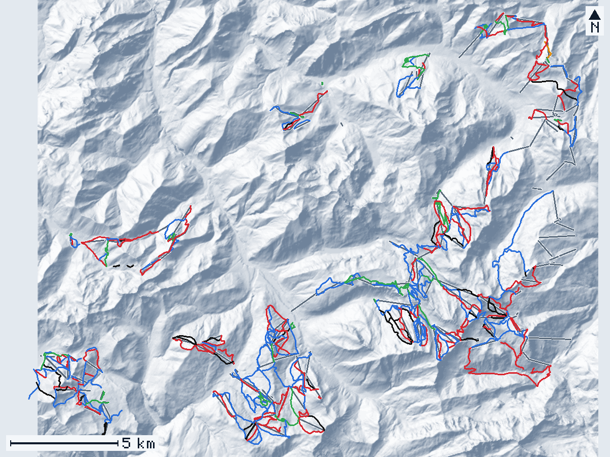
Map of the area
Hover or tap a line for its name and numbers; click to open its page.
- Green
- Blue
- Red
- Black
- Freeride
- Unknown
- lifts
- north is up
- Relief: GeoPeaks, from IGN LiDAR HD and swisstopo swissALTI3D. Runs and lifts: © OpenStreetMap contributors.
Keyboard: Tab goes through the lines, Enter opens one, + and − zoom, the arrows move the map.
Villages
- Les Gets108 runs start nearest · opens in 3D
- Morzine31 runs start nearest · opens in 3D
- Montriondno run starts nearest · opens in 3D
- Avoriaz88 runs start nearest · opens in 3D
- Saint-Jean-d'Aulps33 runs start nearest · opens in 3D
- Abondance10 runs start nearest · opens in 3D
- La Chapelle-d'Abondance20 runs start nearest · opens in 3D
- Châtel27 runs start nearest · opens in 3D
- Torgon2 runs start nearest · opens in 3D
- Morgins7 runs start nearest · opens in 3D
- Champoussin5 runs start nearest · opens in 3D
- Les Crosets49 runs start nearest · opens in 3D
- Champéry1 run starts nearest · opens in 3D
In short
Portes du Soleil is a ski area in France and in Switzerland, around Les Gets, Morzine, Montriond, Avoriaz, Saint-Jean-d'Aulps, Abondance, La Chapelle-d'Abondance, Châtel, Torgon, Morgins, Champoussin, Les Crosets, and Champéry. GeoPeaks maps 381 of its named runs (360 km of run lines) and 214 lifts from OpenStreetMap and measures them on IGN LiDAR HD and swisstopo swissALTI3D: those runs lie between 920 m and 2,247 m.
Runs by difficulty
- Green 52 14 %
- Blue 161 42 %
- Red 124 33 %
- Black 39 10 %
- Black (expert) 3 1 %
- Freeride 1 0 %
- Unknown 1 0 %
Rankings in Portes du Soleil
Steepest
- Bouquetin 84 % · avg. 37 %
- Itinénaire Tronchey 79 % · avg. 46 %
- Chavanette (Le Mur Suisse) 77 % · avg. 38 %
- Combe du Machon 71 % · avg. 45 %
- Les Rhododendrons 69 % · avg. 32 %
Longest
- Ripaille - Grand Paradis 7.17 km · ↓ 849 m
- Tovassière 6.71 km · ↓ 641 m
- Chardon Bleu 4.14 km · ↓ 98 m
- Abricotine 4.13 km · ↓ 554 m
- La Belette 3.87 km · ↓ 330 m
Biggest drop
- Ripaille - Grand Paradis ↓ 849 m · 7.17 km
- Jean Vuarnet ↓ 689 m · 2.29 km
- Le Linga ↓ 662 m · 2.08 km
- Snowcross Crosats ↓ 652 m · 1.81 km
- Tovassière ↓ 641 m · 6.71 km
About these numbers
GeoPeaks measures each named run of OpenStreetMap along its main line, horizontally, on IGN LiDAR HD and swisstopo swissALTI3D. The relief is the one the 3D view draws: a 2 m grid, with the corridors of the runs shaped as groomed runs, so the numbers are close to the ground but not a survey of it. A run drawn as several pieces counts once; runs without a name, areas and runs under 60 m are left out. The steepest 20 m are measured on the line smoothed over 50 m (each 10 m step counts as the median of the five around it), so that a single step of the ground — a road’s cut, a bank — does not count: a steep pitch shorter than about 30 m reads gentler than it is. A run whose line climbs back up more than 15 m, or that is gentle on average with a far steeper short pitch, is left out of the steepest list.
The operator announces 600 km of pistes, 307 pistes, 208 lifts, 12 resorts, and an area of 400 km² (source, read on October 29, 2026). Ski areas count their pistes their own way, so their totals and ours are not the same measure.
Questions
How many runs does Portes du Soleil have?
GeoPeaks measures 381 named runs (360 km of run lines) and 214 lifts mapped in OpenStreetMap. The operator announces 600 km of pistes, 307 pistes, 208 lifts, 12 resorts, and an area of 400 km² (source, read on October 29, 2026).
What is the steepest run in Portes du Soleil?
Bouquetin (near Les Gets): 84 % on its steepest 20 m, measured by GeoPeaks.
What is the longest run in Portes du Soleil?
Ripaille - Grand Paradis (near Les Crosets): 7.17 km, with 849 m of vertical drop.
Which villages are in Portes du Soleil?
GeoPeaks places the runs around Les Gets, Morzine, Montriond, Avoriaz, Saint-Jean-d'Aulps, Abondance, La Chapelle-d'Abondance, Châtel, Torgon, Morgins, Champoussin, Les Crosets, and Champéry.
Runs
Green
- Abricotine 148 m · ↓ 17 m
- Aller Chavanette 254 m · ↓ 18 m
- Barmettes 283 m · ↓ 36 m
- Beuloz 113 m · ↓ 10 m
- Bouchet 304 m · ↓ 42 m
- Champ de ski Plateau 1 269 m · ↓ 31 m
- Champ de ski Plateau 2 284 m · ↓ 31 m
- Chevaly 393 m · ↓ 37 m
- Choucas 3.56 km · ↓ 336 m
- Col Vert 943 m · ↓ 92 m
- Coquelets 178 m · ↓ 26 m
- Douanier 230 m · ↓ 28 m
- Dromonts 408 m · ↓ 28 m
- École 1 124 m · ↓ 13 m
- Espace Dromonts 266 m · ↓ 16 m
- Étangs 126 m · ↓ 15 m
- Farquet 1 338 m · ↓ 47 m
- Jora 268 m · ↓ 36 m
- La Belette 3.87 km · ↓ 330 m
- La Belette 530 m · ↓ 27 m
- La Bray 365 m · ↓ 46 m
- La Chouette 80 m · ↓ 7 m
- La Lécherette 789 m · ↓ 61 m
- La Lécherette 744 m · ↓ 115 m
- Lac 216 m · ↓ 35 m
- Les Favières 1.60 km · ↓ 203 m
- Les Lanches 304 m · ↓ 12 m
- Les Rubis 254 m · ↓ 51 m
- Ludoffaz 123 m · ↓ 10 m
- Marmotte 1.95 km · ↓ 176 m
- Mary 81 m · ↓ 5 m
- Mas Verjus 434 m · ↓ 67 m
- Mossettes 713 m · ↓ 107 m
- Ourson 3.36 km · ↓ 294 m
- Petit Covagny 181 m · ↓ 25 m
- Petit Frémoux 480 m · ↓ 86 m
- Pingouin 467 m · ↓ 72 m
- Piste des Cowboys 679 m · ↓ 69 m
- Piste des Indiens 1.01 km · ↓ 101 m
- Piste Mauve 79 m · ↓ 8 m
- Proclou 1re Glisse 1.98 km · ↓ 144 m
- Proclou 898 m · ↓ 80 m
- Prodains 162 m · ↓ 19 m
- Retour Chavanette 1.38 km · ↓ 109 m
- Retour station Buchilles 857 m · ↓ 67 m
- Retour station 640 m · ↓ 40 m
- Retour station 100 m · ↓ 0 m
- retour station 856 m · ↓ 71 m
- Serraussaix 1.85 km · ↓ 122 m
- Terchette 238 m · ↓ 15 m
- Trashers 214 m · ↓ 26 m
- Zone débutants 831 m · ↓ 47 m
Blue
- 54 567 m · ↓ 60 m
- Abricotine 4.13 km · ↓ 554 m
- Accès Braitaz 664 m · ↓ 83 m
- Accès Brésy 250 m · ↓ 32 m
- Accès Bresy 301 m · ↓ 39 m
- Accès Planey 361 m · ↓ 6 m
- Accès Praz L'Évêque 245 m · ↓ 56 m
- Accès Praz L'Evèque 750 m · ↓ 40 m
- Accès TK Cuboré 464 m · ↓ 73 m
- Aller Chavanette 128 m · ↓ 9 m
- Aller Chavanette 1.03 km · ↓ 100 m
- Belette 883 m · ↓ 194 m
- Bellevue 1.47 km · ↓ 232 m
- Biche Bas 722 m · ↓ 188 m
- Bleue d'Arare 143 m · ↓ 6 m
- Bleue d'Arare 1.86 km · ↓ 396 m
- Bleue de Chavanette 1.87 km · ↓ 348 m
- Bleue du Lac 1.60 km · ↓ 264 m
- Bleue Du Lac 324 m · ↓ 70 m
- Bleuet 3.04 km · ↓ 249 m
- Blue Velvet 1.48 km · ↓ 412 m
- Boulevard des Skieurs 639 m · ↓ 61 m
- Brésy 1.05 km · ↓ 150 m
- Bruyère 1.57 km · ↓ 203 m
- Bruyère 1.60 km · ↓ 199 m
- Buchilles 1 (Stade de slalom) 565 m · ↓ 126 m
- Campanule 1.03 km · ↓ 220 m
- Canevet 454 m · ↓ 69 m
- Chalet Neuf 1.12 km · ↓ 165 m
- Chardon Bleu 4.14 km · ↓ 98 m
- Chaux Longe 616 m · ↓ 74 m
- Chemin des Jeurs 312 m · ↓ 36 m
- Col de Sommand 1.31 km · ↓ 247 m
- Combe à Floret 2.04 km · ↓ 371 m
- Conches 481 m · ↓ 89 m
- Corne Bleue 1.21 km · ↓ 302 m
- Crête 985 m · ↓ 121 m
- Crocus 594 m · ↓ 80 m
- Crosets 928 m · ↓ 182 m
- Crosets 98 m · ↓ 38 m
- Crôt 3.21 km · ↓ 589 m
- Cyclamen 1.82 km · ↓ 243 m
- Didier Défago 2.07 km · ↓ 391 m
- École 2 242 m · ↓ 41 m
- Farquet 2 336 m · ↓ 47 m
- Fornet 1.95 km · ↓ 369 m
- Gentiane 165 m · ↓ 31 m
- Gentiane 3.09 km · ↓ 485 m
- Golf Les Gets 265 m · ↓ 50 m
- Grand Conche 834 m · ↓ 142 m
- Grand Conche 413 m · ↓ 58 m
- Grand Frémoux 1.26 km · ↓ 258 m
- Grand Plan 2.14 km · ↓ 451 m
- Granges 1.80 km · ↓ 226 m
- Graydon bis 351 m · ↓ 104 m
- Graydon 414 m · ↓ 89 m
- Hermine 1.51 km · ↓ 237 m
- Ima 1.60 km · ↓ 36 m over 370 m
- Jean Bernard 1.05 km · ↓ 199 m
- Jonction Aller Chavanette 187 m · ↓ 15 m
- Jonction Bleue d'Arare 189 m · ↓ 25 m
- Jonction Blue Velvet 130 m · ↓ 12 m
- Jonction Mossettes 121 m · ↓ 4 m
- L'Alpage 585 m · ↓ 84 m
- L'Ecuelle 337 m · ↓ 90 m
- L'Hôtel 549 m · ↓ 97 m
- L'Itinéraire 3.44 km · ↓ 445 m
- La Chanterelle 1.13 km · ↓ 271 m
- La Forgne 1.12 km · ↓ 175 m
- La Leiche 2.10 km · ↓ 460 m
- La Traverse 992 m · ↓ 201 m
- Le Chésery 1.70 km · ↓ 283 m
- Le Crôt Variante 420 m · ↓ 52 m
- Le Lac 231 m · ↓ 47 m
- Le Lac 883 m · ↓ 202 m
- Le Lac 931 m · ↓ 134 m
- Léchereuse 847 m · ↓ 157 m
- Les Alpages 653 m · ↓ 177 m
- Les Betex 532 m · ↓ 74 m
- Les Blattins 2.63 km · ↓ 453 m
- Les Fattes 573 m · ↓ 69 m
- Les Favières 584 m · ↓ 130 m
- Les Favières 144 m · ↓ 13 m
- Les freux 1.13 km · ↓ 125 m
- Les Gernes 487 m · ↓ 87 m
- Les Lanches 285 m · ↓ 51 m
- Les Prèses 541 m · ↓ 96 m
- Les Raverettes 882 m · ↓ 161 m
- Les Sapins Bis 464 m · ↓ 88 m
- Les Sapins 832 m · ↓ 146 m over 730 m
- Les Sapins 555 m · ↓ 57 m
- Les Terrasse 891 m · ↓ 84 m
- Les Têtes 1.05 km · ↓ 194 m
- Les Tétras 2.51 km · ↓ 379 m
- Les Trembles 877 m · ↓ 96 m
- Liaison 1.30 km · ↓ 175 m
- Lievre 2.60 km · ↓ 413 m
- Lil'Stash 1.15 km · ↓ 121 m
- Marcheuson 327 m · ↓ 68 m
- Marmotte 1.46 km · ↓ 224 m
- Mélèzes 283 m · ↓ 36 m
- Mélèzes 471 m · ↓ 67 m
- Mercheuson - Planachaux 311 m · ↓ 25 m
- Montée du Sirius 855 m · ↓ 58 m
- Mosettes 398 m · ↓ 39 m
- Mossettes 248 m · ↓ 61 m
- Mossettes 90 m · ↓ 12 m
- Onnaz-Chermeu 1.08 km · ↓ 139 m
- Ourson 895 m · ↓ 207 m
- Panoramique 672 m · ↓ 109 m
- Paquérages 721 m · ↓ 144 m
- Parchets 1.30 km · ↓ 278 m
- Pauvre Conche 1.15 km · ↓ 244 m
- Perce-Neige 320 m · ↓ 54 m
- Pierres Rouges 1.14 km · ↓ 242 m
- Piste B 2.40 km · ↓ 386 m
- Piste C 60 m · ↓ 1 m
- Piste C/Corbeau 1.54 km · ↓ 287 m
- Piste C/Hermine 372 m · ↓ 113 m
- Piste D/Daguet 750 m · ↓ 124 m
- Piste du Lac 2.56 km · ↓ 439 m
- Piste G/Grizzli 1.74 km · ↓ 330 m
- Piste N 944 m · ↓ 81 m
- Piste Pastorale du Follière 92 m · ↓ 6 m
- Place Centrale 94 m · ↓ 3 m
- Place du Snow 297 m · ↓ 1 m
- Planachaux 412 m · ↓ 52 m
- Planachaux - Crosets 470 m · ↓ 45 m
- Portes du Soleil 1.53 km · ↓ 197 m
- Proclou 1.43 km · ↓ 154 m
- Prolays 324 m · ↓ 109 m
- Prolays 1.02 km · ↓ 189 m
- Promenade du Festival 197 m · ↓ 13 m
- Q'mont 422 m · ↓ 91 m
- Recon 1.85 km · ↓ 397 m
- Reine des Pres 1.05 km · ↓ 167 m
- Renardière 1.22 km · ↓ 140 m
- Renardière 934 m · ↓ 118 m
- Retour des Nants 1.72 km · ↓ 171 m
- Retour Hôtel 185 m · ↓ 17 m
- Ripaille 1.39 km · ↓ 236 m
- Route de l'Alpage 112 m · ↓ 8 m
- Route des Crozats 109 m · ↓ 6 m
- Rue des Traineaux 252 m · ↓ 16 m
- Sanglier 675 m · ↓ 73 m
- Snowcross Marmottes 1.52 km · ↓ 360 m
- snowpark 556 m · ↓ 86 m
- Snowpark Arare 901 m · ↓ 225 m
- Stade d'Arare 1.13 km · ↓ 278 m
- Stade François Dides 723 m · ↓ 211 m
- Tetras 881 m · ↓ 206 m
- Tétras 1.83 km · ↓ 283 m
- Tour de Don 612 m · ↓ 136 m
- Tovassière 6.71 km · ↓ 641 m
- Tulipe 1.74 km · ↓ 403 m
- Uski 1.33 km · ↓ 209 m
- Village des Lindarets 260 m · ↓ 18 m
- Violette 1.31 km · ↓ 222 m
- Vorosses 1.34 km · ↓ 302 m
- Zone Vidéo 186 m · ↓ 45 m
- Zore 1.46 km · ↓ 283 m
Red
- 16 Grand Conche 986 m · ↓ 246 m
- 20 Col des Portes du Soleil 1.78 km · ↓ 322 m
- 21 Mossettes 1.06 km · ↓ 303 m
- 33 Pierre à Cornieule 973 m · ↓ 284 m
- 36 1.12 km · ↓ 246 m
- 56 318 m · ↓ 104 m
- Aigle Rouge 342 m · ↓ 89 m
- Alpages 510 m · ↓ 206 m
- Ambresalle 1.20 km · ↓ 281 m
- Arbis 1.66 km · ↓ 504 m
- Barbossine 83 m · ↓ 4 m
- Belle Mouille 1.19 km · ↓ 260 m
- Blanchot 379 m · ↓ 103 m
- Blanchot 551 m · ↓ 191 m
- Boarder Cross 679 m · ↓ 93 m
- Brésy 889 m · ↓ 180 m
- Buchilles 2 267 m · ↓ 92 m
- Cabri 1.48 km · ↓ 359 m
- Casse Noisettes 733 m · ↓ 271 m
- Casse Noisettes 179 m · ↓ 83 m
- Cerf Bas 273 m · ↓ 88 m
- Cerf Haut 332 m · ↓ 61 m
- Chamois 937 m · ↓ 281 m
- Chargeau 594 m · ↓ 120 m
- Chaux Fleurie 922 m · ↓ 219 m
- Chemin de la Chèvrerie à Foron 1.61 km · ↓ 160 m
- Chermillon 707 m · ↓ 225 m
- Chevrelles 1.65 km · ↓ 319 m
- Col de Croix 536 m · ↓ 54 m
- Conches 341 m · ↓ 115 m
- Corne Rouge 918 m · ↓ 297 m
- Coutalays 935 m · ↓ 199 m
- Creux de la neige 1.19 km · ↓ 266 m
- Crosets 639 m · ↓ 202 m
- Cuboré Montriond 497 m · ↓ 160 m
- Djeu des Têtes 1.70 km · ↓ 388 m
- Dronaires 1.02 km · ↓ 179 m
- Eglantine 1.31 km · ↓ 266 m
- Epervier 1.09 km · ↓ 283 m
- Eterlou 954 m · ↓ 181 m
- Fenerêts 1.18 km · ↓ 277 m
- Fleury 386 m · ↓ 102 m
- Folière 1.30 km · ↓ 262 m
- Follys 1.19 km · ↓ 287 m
- Gelinotte 393 m · ↓ 105 m
- Graydon 1.40 km · ↓ 255 m
- Jean Vuarnet 2.29 km · ↓ 689 m
- Jonction Vautna 125 m · ↓ 23 m
- L'Aigle 854 m · ↓ 214 m
- L'Aity 921 m · ↓ 277 m
- L'Écureuil 1.37 km · ↓ 391 m
- L'Épervier 1.10 km · ↓ 343 m
- L'Eterlou 961 m · ↓ 168 m
- La Casse Noisette 141 m · ↓ 3 m
- La Combe 642 m · ↓ 156 m
- La Combe 1.09 km · ↓ 222 m
- La Combe 1.51 km · ↓ 357 m
- La Combe 740 m · ↓ 154 m
- La Grande Terche 2.16 km · ↓ 589 m
- La Perdrix Blanche 1.85 km · ↓ 402 m
- La Savine 559 m · ↓ 177 m
- La Traverse (nouvelle liaison 2025) 297 m · ↓ 65 m
- Lac Léman 2.08 km · ↓ 419 m
- Le Châl 1.40 km · ↓ 408 m
- Le Chamois 868 m · ↓ 238 m
- Le Lac 992 m · ↓ 116 m
- Le Linga 2.08 km · ↓ 662 m
- Le Mur 302 m · ↓ 87 m
- Le Stade 545 m · ↓ 155 m
- Le Stade 716 m · ↓ 230 m
- Les Blanchots 608 m · ↓ 129 m
- Les Chamois 541 m · ↓ 171 m
- Les Combes 2.05 km · ↓ 432 m
- Les Lanches 979 m · ↓ 182 m
- Les Lanches 300 m · ↓ 103 m
- Les Lanches 265 m · ↓ 51 m
- Les Mottes 437 m · ↓ 102 m
- Les Mouflons 2.09 km · ↓ 355 m
- Les Têtes 691 m · ↓ 194 m
- Lièvre 1.60 km · ↓ 377 m
- Lynx 948 m · ↓ 320 m
- Marcheuson 362 m · ↓ 85 m
- Marmotte 1.62 km · ↓ 403 m
- Mélèzes 1.75 km · ↓ 405 m
- Mossettes 81 m · ↓ 12 m
- Mossettes 702 m · ↓ 154 m
- Mouille Noire 596 m · ↓ 139 m over 450 m
- Mur Patenaille 308 m · ↓ 103 m
- Onnaz 456 m · ↓ 142 m
- Orchis 992 m · ↓ 233 m
- Patenaille 852 m · ↓ 146 m
- Pauvre Conche 407 m · ↓ 78 m
- Piste A/Abeille 548 m · ↓ 192 m
- Piste B 2.41 km · ↓ 355 m
- Piste entrainement ski club 662 m · ↓ 171 m
- Piste F/Fouine 1.71 km · ↓ 399 m
- Piste R/Renard 816 m · ↓ 187 m
- Piste V 526 m · ↓ 141 m
- Planachaux - Grand Paradis 1.35 km · ↓ 230 m
- Planachaux - Grand Paradis 1.30 km · ↓ 345 m
- Planachaux 809 m · ↓ 236 m
- Pointe 186 m · ↓ 49 m
- Pré-la-Joux 1.51 km · ↓ 374 m
- Pré-la-Joux 1.38 km · ↓ 364 m
- Retour village 2.04 km · ↓ 434 m
- Rhodo 593 m · ↓ 120 m
- Rhodos 519 m · ↓ 147 m
- Ripaille - Grand Paradis 7.17 km · ↓ 849 m
- Rochassons 1.65 km · ↓ 321 m
- Rochassons 867 m · ↓ 253 m
- Route de Planachaux 1.14 km · ↓ 122 m
- Roy 653 m · ↓ 139 m
- Sautenailles 977 m · ↓ 206 m
- Snow Park 238 m · ↓ 37 m
- Snowcross Pschott 1.18 km · ↓ 315 m
- Stade 749 m · ↓ 232 m
- Stade Grande Ours 698 m · ↓ 208 m
- Stade Tête au Boeuf 500 m · ↓ 171 m
- Tannes 1.21 km · ↓ 271 m
- Vaineuve 481 m · ↓ 144 m
- Variante Cuboré 523 m · ↓ 147 m
- Vautna 2.43 km · ↓ 444 m
- Véran 240 m · ↓ 97 m
- Véran 283 m · ↓ 82 m
Black
- 15 Grand Conche 693 m · ↓ 159 m
- 18 Pauvre Conche 955 m · ↓ 288 m
- 22 Loquet 1.36 km · ↓ 395 m
- 23 Conchette 864 m · ↓ 218 m
- 36 145 m · ↓ 53 m
- Aigle 440 m · ↓ 127 m
- Aigle noir 550 m · ↓ 190 m
- Arête des Intrets 399 m · ↓ 197 m
- Arête des Intrets 695 m · ↓ 309 m
- Barbossine 1.87 km · ↓ 435 m
- Bouquetin 957 m · ↓ 354 m
- Chevreuil 1.03 km · ↓ 363 m
- Combe du Machon 695 m · ↓ 314 m
- Combette 989 m · ↓ 369 m
- Corne Noire 534 m · ↓ 207 m
- Coupe du Monde 1.23 km · ↓ 328 m
- Creux 1.10 km · ↓ 397 m
- Crozats 230 m · ↓ 73 m
- Didier Défago Black 182 m · ↓ 104 m
- Françoise Macchi 984 m · ↓ 333 m
- Gazelle 1.10 km · ↓ 342 m
- La Combe Perret 1.29 km · ↓ 377 m over 1.13 km
- La Face 449 m · ↓ 147 m
- Le Corbeau 386 m · ↓ 137 m
- Le Vélard 1.63 km · ↓ 442 m
- Les Chamois 97 m · ↓ 19 m
- Les Renards 1.23 km · ↓ 401 m
- Les Rhododendrons 1.37 km · ↓ 439 m
- Les Vous 342 m · ↓ 80 m
- Les Vous 337 m · ↓ 108 m
- Mouflon 1.33 km · ↓ 403 m
- Myrtilles 669 m · ↓ 231 m
- Olympique 1.14 km · ↓ 422 m
- Ombriuex "le lard" 832 m · ↓ 330 m
- Planey (Stade de slalom) 815 m · ↓ 238 m
- Snowcross Crosats 1.81 km · ↓ 652 m
- Snowcross La Frontalière 1.10 km · ↓ 406 m
- Vautna Noire 406 m · ↓ 151 m
- Yéti 875 m · ↓ 263 m
Black (expert)
- Chavanette (Le Mur Suisse) 852 m · ↓ 326 m
- Le Haut Fleury 680 m · ↓ 233 m
- Planey 598 m · ↓ 202 m
Freeride
- Itinénaire Tronchey 875 m · ↓ 403 m
Unknown
- Bleue d'Arare 239 m · ↓ 19 m
Lifts
- Aiguille des Champeys Chairlift · ↑ 360 m
- Arare 1 Drag lift · ↑ 225 m
- Arare 2 Drag lift · ↑ 225 m
- Ardent Gondola · ↑ 298 m
- Atray Chairlift · ↑ 297 m
- Babylift Planachaux Drag lift · ↑ 26 m
- Bambi Drag lift · ↑ 47 m
- Barbossine Chairlift · ↑ 443 m
- Barmettes Drag lift · ↑ 36 m
- Baron Drag lift · ↑ 87 m
- Belvédère Chairlift · ↑ 76 m
- Betex Drag lift · ↑ 63 m
- Bochasses Chairlift · ↑ 377 m
- Bossons Drag lift · ↑ 141 m
- Bouchet Drag lift · ↑ 39 m
- Boule de Gomme Drag lift · ↑ 63 m
- Bray Drag lift · ↑ 46 m
- Brésy Drag lift · ↑ 180 m
- Brochaux Chairlift · ↑ 411 m
- Buchilles Drag lift · ↑ 126 m
- Cabri Drag lift · ↑ 115 m
- Canevet Drag lift · ↑ 69 m
- Cases Chairlift · ↑ 442 m
- Chalet Neuf 1 Drag lift · ↑ 232 m
- Chalet Neuf 2 Drag lift · ↑ 232 m
- Chamossière Express Chairlift · ↑ 504 m
- Champéry - Croix de Culet Cable car · ↑ 899 m
- Champeys Drag lift · ↑ 177 m
- Chapelle Drag lift · ↑ 54 m
- Chapelle Drag lift · ↑ 12 m
- Chargeau Chairlift · ↑ 189 m
- Charniaz Express Chairlift · ↑ 352 m
- Chaux Chairlift · ↑ 312 m
- Chaux des Rosées Chairlift · ↑ 410 m
- Chaux Fleurie Chairlift · ↑ 416 m
- Chaux Longe Drag lift · ↑ 67 m
- Chavanette Chairlift · ↑ 331 m
- Chavanette 1 Drag lift · ↑ 344 m
- Chavanette 2 Drag lift · ↑ 344 m
- Chavannes Gondola · ↑ 315 m
- Chavannes Express Chairlift · ↑ 449 m
- Chermeu Drag lift · ↑ 160 m
- Chéry Nord Chairlift · ↑ 405 m
- Chevaly 1 Drag lift · ↑ 38 m
- Chevaly 2 Drag lift · ↑ 39 m
- Choucas Chairlift · ↑ 349 m
- Col de Sommand Chairlift · ↑ 354 m
- Combe Drag lift · ↑ 264 m
- Combes Chairlift · ↑ 438 m
- Conche 2000 Drag lift · ↑ 151 m
- Conches Chairlift · ↑ 392 m
- Contrebandiers Drag lift · ↑ 73 m
- Coqs 1 Drag lift · ↑ 149 m
- Coqs 2 Drag lift · ↑ 149 m
- Coquelets Drag lift · ↑ 26 m
- Corbeau Drag lift · ↑ 157 m
- Corbeau Chairlift · ↑ 413 m
- Corne 1 Drag lift · ↑ 158 m
- Corne 2 Drag lift · ↑ 302 m
- Cornebois Chairlift · ↑ 446 m
- Crêt Béni Chairlift · ↑ 350 m
- Crintat Drag lift · ↑ 107 m
- Croix Chairlift · ↑ 130 m
- Crosets Chairlift · ↑ 253 m
- Crusaz Chairlift · ↑ 328 m
- Cuboré Drag lift · ↑ 165 m
- Cuboré Chairlift · ↑ 144 m
- Cuboré Chairlift · ↑ 161 m
- Culet 2 Drag lift · ↑ 244 m
- Dahu Drag lift · ↑ 27 m
- Débutants Drag lift · ↑ 35 m
- Derrière Pertuis Drag lift · ↑ 245 m
- Djeu des Têtes Drag lift · ↑ 375 m
- Douanier Drag lift · ↑ 33 m
- Dromonts 1 Drag lift · ↑ 16 m
- Dromonts 1 Drag lift · ↑ 1 m
- Dromonts 1 Drag lift · ↑ 10 m
- Dromonts 2 Drag lift · ↑ 16 m
- Dromonts 2 Drag lift · ↑ 0 m
- Dromonts 2 Drag lift · ↑ 10 m
- Ébauds Drag lift · ↑ 2 m
- Écho Alpin Chairlift · ↑ 525 m
- École 1 Drag lift · ↑ 13 m
- École 2 Drag lift · ↑ 41 m
- Écoles 1 Drag lift · ↑ 30 m
- Écoles 2 Drag lift · ↑ 30 m
- Écottis Drag lift · ↑ 153 m
- Esserailloux Drag lift · ↑ 288 m
- Essert Gondola · ↑ 431 m
- Étangs Drag lift · ↑ 15 m
- Farquet Drag lift · ↑ 47 m
- Folliets du Golf Chairlift · ↑ 185 m
- Follys Drag lift · ↑ 104 m
- Follys 1 Drag lift · ↑ 177 m
- Follys 2 Drag lift · ↑ 177 m
- Fontaines Chairlift · ↑ 231 m
- Fornet Chairlift · ↑ 409 m
- Fys Chairlift · ↑ 392 m
- Gabelou Chairlift · ↑ 5 m
- Géant Drag lift · ↑ 75 m
- Gourtet Drag lift · ↑ 7 m
- Grand Conche Chairlift · ↑ 449 m
- Grand Cry Drag lift · ↑ 54 m
- Grand Frémoux Drag lift · ↑ 258 m
- Grand Paradis Chairlift · ↑ 633 m
- Grande Terche Gondola · ↑ 559 m
- Grandes Combes Chairlift · ↑ 702 m
- Graydon Chairlift · ↑ 255 m
- Gueilly Drag lift · ↑ 50 m
- Hameau Drag lift · ↑ 38 m
- Haut Fleury Chairlift · ↑ 477 m
- Hôtel Drag lift · ↑ 168 m
- Jora Drag lift · ↑ 36 m
- La Pointe Chairlift · ↑ 284 m
- Lac Drag lift · ↑ 35 m
- Lac Drag lift · ↑ 202 m
- Lac Drag lift · ↑ 78 m
- Lac-Intrêts Chairlift · ↑ 492 m
- Lanches Drag lift · ↑ 51 m
- Léchère Chairlift · ↑ 234 m
- Les Luttins Magic carpet · ↑ 10 m
- Lindarets Chairlift · ↑ 379 m
- Linga Chairlift · ↑ 596 m
- Loy Drag lift · ↑ 11 m
- Marcheuson Drag lift · ↑ 106 m
- Mary Magic carpet · ↑ 5 m
- Mas Verjus Drag lift · ↑ 19 m
- Mont Chéry Gondola · ↑ 372 m
- Morclan Chairlift · ↑ 349 m
- Morgins-Foilleuse Gondola · ↑ 504 m
- Mossettes Chairlift · ↑ 570 m
- Mossettes Chairlift · ↑ 665 m
- Mouille au Roy Drag lift · ↑ 108 m
- Mouilles Chairlift · ↑ 212 m
- Nabor Chairlift · ↑ 74 m
- Nauchets Express Chairlift · ↑ 270 m
- Nyon Cable car · ↑ 392 m
- Onnaz Drag lift · ↑ 210 m
- Panthiaz Gondola · ↑ 464 m
- Pauvre Conche Chairlift · ↑ 303 m
- Pêche Drag lift · ↑ 34 m
- Perrières Express Chairlift · ↑ 422 m
- Petit Châtel Chairlift · ↑ 233 m
- Petit Covagny Drag lift · ↑ 25 m
- Petit Frémoux Drag lift · ↑ 86 m
- Pierre Longue Chairlift · ↑ 341 m
- Pierre Rouge Chairlift · ↑ 242 m
- Piou Piou Magic carpet · ↑ 2 m
- Planachaux Chairlift · ↑ 254 m
- Planey Drag lift · ↑ 177 m
- Planeys Chairlift · ↑ 377 m
- Plateau Chairlift · ↑ 64 m
- Pléney Gondola · ↑ 513 m
- Pointe de l'Au Chairlift · ↑ 364 m
- Pointe de Nyon Chairlift · ↑ 542 m
- Poireaux 1 Drag lift · ↑ 52 m
- Poireaux 2 Drag lift · ↑ 52 m
- Poussinets Drag lift · ↑ 12 m
- Poussins Drag lift · ↑ 15 m
- Praz l'Évèque Chairlift · ↑ 379 m
- Pré Favre Chairlift · ↑ 265 m
- Pré la Joux Chairlift · ↑ 492 m
- Pré la Joux Magic carpet · ↑ 20 m
- Pré-la-Vieille Drag lift · ↑ 54 m
- Prés 1 Drag lift · ↑ 72 m
- Prés 2 Drag lift · ↑ 63 m
- Proclou Chairlift · ↑ 236 m
- Prodains Drag lift · ↑ 19 m
- Prodains Express 3S Gondola · ↑ 582 m
- Prolays Chairlift · ↑ 446 m
- Queyset Drag lift · ↑ 60 m
- Ranfoilly Express Chairlift · ↑ 417 m
- Raverettes Chairlift · ↑ 123 m
- Ripaille 1 Drag lift · ↑ 239 m
- Ripaille 2 Drag lift · ↑ 239 m
- Rochassons Chairlift · ↑ 289 m
- Rosta Chairlift · ↑ 264 m
- Roy Chairlift · ↑ 200 m
- Rubis Drag lift · ↑ 51 m
- Sepaya I Drag lift · ↑ 245 m
- Sepaya II Drag lift · ↑ 161 m
- Séraussaix Chairlift · ↑ 137 m
- Snowly Drag lift · ↑ 19 m
- Stade Drag lift · ↑ 152 m
- Stade Chairlift · ↑ 196 m
- Stade Drag lift · ↑ 41 m
- Super-Châtel Gondola · ↑ 417 m
- Super-Morzine Gondola · ↑ 488 m
- Surf Drag lift · ↑ 60 m
- Tapis Chavannes Magic carpet · ↑ 12 m
- Tapis de l'Aiglon Magic carpet · ↑ 7 m
- Tapis de Nabor Magic carpet · ↑ 3 m
- Tapis de Super Yeti Magic carpet · ↑ 10 m
- Tapis Platais Magic carpet · ↑ 8 m
- Telecorde Mouille au Blé Drag lift · ↑ 12 m
- Télésiège de Braitaz Chairlift · ↑ 408 m
- Télésiège des Portes du Soleil Chairlift · ↑ 263 m
- Téléski de Fleury Drag lift · ↑ 102 m
- Terchette Drag lift · ↑ 15 m
- Tête des Crêts Drag lift · ↑ 171 m
- Têtes Chairlift · ↑ 327 m
- Têtes Chairlift · ↑ 227 m
- Torchon Chairlift · ↑ 376 m
- Tour Chairlift · ↑ 175 m
- Tour de Don Drag lift · ↑ 136 m
- Trashers Drag lift · ↑ 26 m
- Tronchey Chairlift · ↑ 551 m
- Troncs Express Chairlift · ↑ 265 m
- Truche Drag lift · ↑ 41 m
- Turche Drag lift · ↑ 300 m
- Véran Chairlift · ↑ 280 m
- Vieux Chêne Drag lift · ↑ 41 m
- Viking Magic carpet · ↑ 19 m
- Zore Chairlift · ↑ 304 m