
Which run for your level?
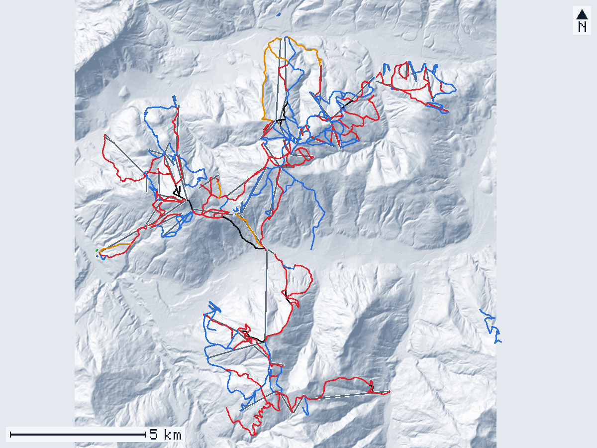
Map of the area
Hover or tap a line for its name and numbers; click to open its page.
- Green
- Blue
- Red
- Black
- Freeride
- lifts
- north is up
- Relief: GeoPeaks, from BEV ALS DTM 1 m. Runs and lifts: © OpenStreetMap contributors.
Keyboard: Tab goes through the lines, Enter opens one, + and − zoom, the arrows move the map.
Villages
- Ellmau44 runs start nearest · opens in 3D
- Going12 runs start nearest · opens in 3D
- Scheffau18 runs start nearest · opens in 3D
- Söll16 runs start nearest · opens in 3D
- Itter4 runs start nearest · opens in 3D
- Hopfgarten16 runs start nearest · opens in 3D
- Brixen im Thale48 runs start nearest · opens in 3D
- Westendorf41 runs start nearest · opens in 3D
In short
SkiWelt Wilder Kaiser is a ski area in Austria, around Ellmau, Going, Scheffau, Söll, Itter, Hopfgarten, Brixen im Thale, and Westendorf. GeoPeaks maps 199 of its named runs (196 km of run lines) and 80 lifts from OpenStreetMap and measures them on BEV ALS DTM 1 m: those runs lie between 609 m and 1,861 m.
Runs by difficulty
- Green 1 1 %
- Blue 98 49 %
- Red 81 41 %
- Black 13 7 %
- Freeride 6 3 %
Rankings in SkiWelt Wilder Kaiser
Steepest
- Black Pipe 73 % · avg. 55 %
- Black Eagle 67 % · avg. 47 %
- Hartkaiserbahn Talabfahrt 66 % · avg. 46 %
- Alpe Seite 65 % · avg. 41 %
- Trapbergabfahrt 65 % · avg. 36 %
Longest
- Skiabfahrt Windau 5.26 km · ↓ 897 m
- Kandleralm Abfahrt 5.01 km · ↓ 1,027 m
- Skiroute Schrandl 4.89 km · ↓ 523 m
- Ki-West Abfahrt 4.68 km · ↓ 856 m
- Tanzer Abfahrt 4.14 km · ↓ 860 m
Biggest drop
- Kandleralm Abfahrt ↓ 1,027 m · 5.01 km
- Moderer Route ↓ 914 m · 3.32 km
- Skiabfahrt Windau ↓ 897 m · 5.26 km
- Tanzer Abfahrt ↓ 860 m · 4.14 km
- Ki-West Abfahrt ↓ 856 m · 4.68 km
About these numbers
GeoPeaks measures each named run of OpenStreetMap along its main line, horizontally, on BEV ALS DTM 1 m. The relief is the one the 3D view draws: a 2 m grid, with the corridors of the runs shaped as groomed runs, so the numbers are close to the ground but not a survey of it. A run drawn as several pieces counts once; runs without a name, areas and runs under 60 m are left out. The steepest 20 m are measured on the line smoothed over 50 m (each 10 m step counts as the median of the five around it), so that a single step of the ground — a road’s cut, a bank — does not count: a steep pitch shorter than about 30 m reads gentler than it is. A run whose line climbs back up more than 15 m, or that is gentle on average with a far steeper short pitch, is left out of the steepest list.
The operator announces 275 km of pistes and 81 lifts (source, read on October 29, 2026). Ski areas count their pistes their own way, so their totals and ours are not the same measure.
Questions
How many runs does SkiWelt Wilder Kaiser have?
GeoPeaks measures 199 named runs (196 km of run lines) and 80 lifts mapped in OpenStreetMap. The operator announces 275 km of pistes and 81 lifts (source, read on October 29, 2026).
What is the steepest run in SkiWelt Wilder Kaiser?
Black Pipe (near Hopfgarten): 73 % on its steepest 20 m, measured by GeoPeaks.
What is the longest run in SkiWelt Wilder Kaiser?
Skiabfahrt Windau (near Westendorf): 5.26 km, with 897 m of vertical drop.
Which villages are in SkiWelt Wilder Kaiser?
GeoPeaks places the runs around Ellmau, Going, Scheffau, Söll, Itter, Hopfgarten, Brixen im Thale, and Westendorf.
Runs
Green
- Högerfeld 93 m · ↓ 5 m
Blue
- 100b 2.69 km · ↓ 443 m
- 100b Astbergbahn Talabfahrt 93 m · ↓ 15 m
- 102a 983 m · ↓ 218 m
- 102b 829 m · ↓ 177 m
- 107 Lanzenberg Abfahrt 332 m · ↓ 53 m
- 109 686 m · ↓ 50 m
- 24a Schernthann 188 m · ↓ 43 m
- 25a Foischingabfahrt 498 m · ↓ 114 m
- 25b - Foischingabfahrt b 521 m · ↓ 104 m
- 26 - Skiweg Klaus 639 m · ↓ 49 m
- 2a 226 m · ↓ 50 m
- 31 274 m · ↓ 39 m
- 61a 2.26 km · ↓ 355 m
- 62 414 m · ↓ 32 m
- 64 734 m · ↓ 111 m
- 65 489 m · ↓ 48 m
- 78 459 m · ↓ 40 m
- 80 3.56 km · ↓ 698 m
- 81 778 m · ↓ 113 m
- 87a 141 m · ↓ 30 m
- 87a Umfahrung Seppenbauer 1.24 km · ↓ 44 m
- 90 195 m · ↓ 38 m
- 91 1.37 km · ↓ 303 m
- 96c 599 m · ↓ 59 m
- 97a 332 m · ↓ 83 m
- 97b 1.26 km · ↓ 250 m
- 98 1.30 km · ↓ 288 m
- 99 787 m · ↓ 149 m
- 99 342 m · ↓ 40 m
- Astbergbahn Talabfahrt 379 m · ↓ 75 m
- Babylift - Abfahrt 123 m · ↓ 9 m
- Bärenlift Abfahrt 389 m · ↓ 31 m
- Bodenschmiedfeld 61 m · ↓ 12 m
- Brandstadl Abfahrt Heralm 77 m · ↓ 19 m
- Brandstadl Talabfahrt Knollern 1.94 km · ↓ 301 m
- Brandstadl Talabfahrt Schwarzach 1.22 km · ↓ 252 m
- Familienabfahrt 1.29 km · ↓ 219 m
- Filzboden Abfahrt 687 m · ↓ 97 m
- Fleck 3.34 km · ↓ 374 m over 3.14 km
- Foischingabfahrt 857 m · ↓ 122 m
- Foischingabfahrt a 1.67 km · ↓ 390 m
- Foischingabfahrt c 581 m · ↓ 125 m
- Funslope 352 m · ↓ 52 m
- Gampenkogelabfahrt II 1.07 km · ↓ 135 m
- Hartkaiserbahn Talabfahrt 463 m · ↓ 97 m
- Hochbrixen Abfahrt 1.76 km · ↓ 280 m
- Hochsöll Foisching 3.47 km · ↓ 367 m
- Hohe Salve - Rigi 255 m · ↓ 38 m
- Höhninger Abfahrt 718 m · ↓ 134 m
- Hollernabfahrt 2.61 km · ↓ 519 m
- Holzalm Abfahrt 1.83 km · ↓ 393 m
- Joch Abfahrt 883 m · ↓ 180 m
- Kaiser-Übungslift 128 m · ↓ 11 m
- Kaiserexpress 874 m · ↓ 157 m
- Keat - Antlasseeabfahrt 138 m · ↓ 26 m
- Keat-Antlasseeabfahrt 3.19 km · ↓ 395 m
- Kirchbichl Abfahrt 443 m · ↓ 64 m
- Knollnabfahrt 413 m · ↓ 30 m
- Köglbahn 1.01 km · ↓ 228 m
- Laubkogel Abfahrt 220 m · ↓ 41 m
- nach Ellmau 1.40 km · ↓ 125 m
- Neuhögen Abfahrt 425 m · ↓ 105 m
- Neuhögen Abfahrt 1.10 km · ↓ 278 m
- Osthang - Abfahrten 239 m · ↓ 7 m
- Poldangerabfahrt 113 m · ↓ 30 m
- Rigi - Kraftalm 750 m · ↓ 88 m
- Rigi - Kraftalm Skiweg 864 m · ↓ 63 m
- Rinnerabfahrt 755 m · ↓ 148 m
- Salvenmoos 432 m · ↓ 72 m
- Schusterbühel Abfahrt 435 m · ↓ 22 m
- Skiabfahrt Windau 5.26 km · ↓ 897 m
- Skischullift Abfahrt 142 m · ↓ 11 m
- Skiweg Fleiding Nord 1.23 km · ↓ 170 m
- Skiweg Hartkaiser Talabfahrt 676 m · ↓ 96 m
- Steindlabfahrt 926 m · ↓ 171 m
- Sternfeld Abfahrten 135 m · ↓ 9 m
- Stöcklabfahrt 531 m · ↓ 73 m
- Stöcklabfahrt 302 m · ↓ 71 m
- Talabfahrt Hopfgarten 371 m · ↓ 60 m
- Tanzboden Abfahrt 596 m · ↓ 141 m
- Tanzer Abfahrt 4.14 km · ↓ 860 m
- Übungslift Abfahrt 135 m · ↓ 7 m
- Übungslift Berg Abfahrt 171 m · ↓ 15 m
- Übungslift Dorf - Abfahrt 175 m · ↓ 19 m
- Übungslift Hochbrixen Abfahrt 165 m · ↓ 17 m
- Übungswiese Samerfeld 619 m · ↓ 70 m
- Übungswiese Sammerfeld 289 m · ↓ 30 m
- Übungswiese Schneeberg 628 m · ↓ 83 m
- Verbindung Aualm-Osthang 1.17 km · ↓ 132 m
- Verbindung Chor Mittel/Hollernabfahrt 268 m · ↓ 51 m
- Verbindung Eiberg - Ellmau/Going 821 m · ↓ 127 m
- Verbindung Osthang-Südhang 1.03 km · ↓ 128 m
- Verbindung Ostlift - Tanzboden 318 m · ↓ 44 m
- Verbindung Südhang Aualm 453 m · ↓ 14 m
- Verbindung Südhang Osthang 674 m · ↓ 92 m
- Zauberteppich Astberg 113 m · ↓ 10 m
- Zinsbergabfahrt 1.75 km · ↓ 333 m
- zur Almbahn 1.47 km · ↓ 199 m
Red
- 100 621 m · ↓ 206 m
- 100a 573 m · ↓ 175 m
- 100d 1.05 km · ↓ 57 m
- 102 854 m · ↓ 237 m
- 2 Kälberalm Abfahrt 125 m · ↓ 26 m
- 20 - Talabfahrt Hopfgarten a 2.58 km · ↓ 533 m
- 24a Schernthannabfahrt 1.01 km · ↓ 314 m
- 31, 31a, 31b 154 m · ↓ 19 m
- 31 398 m · ↓ 107 m
- 51b Silleralmschiweg 201 m · ↓ 9 m
- 60 1.36 km · ↓ 267 m
- 80a 612 m · ↓ 100 m
- 80a 1.70 km · ↓ 407 m
- 84 689 m · ↓ 145 m
- 87 203 m · ↓ 40 m
- 87 Ranhart 484 m · ↓ 117 m
- 87 Ranhart 481 m · ↓ 141 m
- 90 2.68 km · ↓ 483 m
- 97 597 m · ↓ 170 m
- 97a 657 m · ↓ 224 m
- 98a 811 m · ↓ 267 m
- Alpenrosenabfahrt 1.79 km · ↓ 448 m
- Astbergbahn Talabfahrt "Viehalp" 683 m · ↓ 214 m
- Aualm - Abfahrten 1.19 km · ↓ 288 m
- Brixen Abfahrt 1.50 km · ↓ 360 m
- Eiberg I Abfahrten 442 m · ↓ 120 m
- Eiberg II - Abfahrten 545 m · ↓ 144 m
- Ellmau Zentrum 948 m · ↓ 139 m
- Ellmererabfahrt 1.61 km · ↓ 469 m
- Filzboden Abfahrt 1.17 km · ↓ 214 m
- Filzboden Abfahrt 2.07 km · ↓ 406 m
- Fleidingabfahrt 1.49 km · ↓ 280 m
- Gampenkogelabfahrt I 828 m · ↓ 209 m
- Geschwindigkeits-Messstrecke Filzboden 164 m · ↓ 36 m
- Geschwindigkeitsmessstrecke 71 m · ↓ 21 m
- Götschen Abfahrt 2.26 km · ↓ 410 m
- Hexen6er 1.18 km · ↓ 370 m
- Hochsöll 1.85 km · ↓ 396 m
- Hohe Salve - Kraftalmabfahrt 861 m · ↓ 190 m
- Hohe Salve - Rigi - Mittelstation 1.28 km · ↓ 351 m
- Hohe Salve - Rigi 1.11 km · ↓ 286 m
- Höhninger Abfahrt 406 m · ↓ 122 m
- Holzalm Abfahrt 175 m · ↓ 66 m
- Joch Abfahrt 2.22 km · ↓ 536 m
- Kaiserexpress 461 m · ↓ 128 m
- Kälberalm Abfahrt 1.45 km · ↓ 347 m
- Kälberalm Südabfahrt 1.17 km · ↓ 260 m
- Kandleralm Abfahrt 5.01 km · ↓ 1,027 m
- Kasbühelweg 1.96 km · ↓ 250 m
- Kaslach Abfahrt 444 m · ↓ 121 m
- Keatabfahrt 1.26 km · ↓ 321 m
- Ki-West Abfahrt 4.68 km · ↓ 856 m
- Kraftalm - Kasbichl b 432 m · ↓ 109 m
- Kummeralmbahn Abfahrt II 841 m · ↓ 222 m
- Kummereralm - Abfahrt 832 m · ↓ 186 m
- Mulden Abfahrten 540 m · ↓ 142 m
- Neuhögen Abfahrt 708 m · ↓ 54 m
- Rigi - Kraftalm 371 m · ↓ 63 m
- Rigi-Mittelstation Hopfgarten 747 m · ↓ 163 m
- Rigiabfahrt 977 m · ↓ 316 m
- Schernthannabfahrt 180 m · ↓ 43 m
- Schmiedalm 1.25 km · ↓ 329 m
- Silleralmabfahrt 1.55 km · ↓ 265 m
- Skimovie Strecke 228 m · ↓ 82 m
- Skiroute 80c nach Ellmau 3.15 km · ↓ 406 m
- Skiroute 80d Jägerhütte bis Einmüdnung 80c 894 m · ↓ 199 m
- Skiroute Hampfer 1.66 km · ↓ 604 m
- Skiroute Schrandl 4.89 km · ↓ 523 m
- Südhang - Abfahrten 631 m · ↓ 209 m
- Talabfahrt Itter 3.24 km · ↓ 670 m
- Talkaserabfahrt 629 m · ↓ 156 m
- Tanzboden Abfahrt 243 m · ↓ 89 m
- Tanzboden Abfahrt 208 m · ↓ 76 m
- Trapbergabfahrt 681 m · ↓ 247 m
- Verbindung Eiberg - Aualm 800 m · ↓ 112 m
- Verbindung Eiberg - Mulden 552 m · ↓ 107 m
- Verbindung Filzboden - Aualm 426 m · ↓ 111 m
- Verbindung Muldenlift-Kummeralmbahn 593 m · ↓ 74 m
- Verbindung Osthang Berg -Südhang 661 m · ↓ 180 m
- Vetterstätt Abfahrten 880 m · ↓ 145 m
- Windaubergabfahrt I 1.12 km · ↓ 273 m
Black
- 2c Südabfahrt-Hohe Salve 450 m · ↓ 196 m
- Alpe Seite 1.05 km · ↓ 431 m
- Black Eagle 727 m · ↓ 340 m
- Black Pipe 303 m · ↓ 166 m
- Brandstadl Talabfahrt 353 m · ↓ 139 m
- Brandstadl Talabfahrt 4EUB 290 m · ↓ 81 m
- Brandstadl Talabfahrt Abfahrt S 631 m · ↓ 237 m
- Hartkaiserbahn Talabfahrt 530 m · ↓ 243 m
- Kandleralm Abfahrt 254 m · ↓ 107 m
- Kandleralm Abfahrt 260 m · ↓ 133 m
- Kaslach Abfahrt 2.10 km · ↓ 558 m
- Ki-West Abfahrt 317 m · ↓ 123 m
- Lärchenhang 458 m · ↓ 146 m
Freeride
- 20b - Talabfahrt Hopfgarten b 1.23 km · ↓ 259 m
- Brandstadl Talabfahrt Bärbichel 1.66 km · ↓ 255 m
- Moderer Route 3.32 km · ↓ 914 m
- Silleralmschiweg 647 m · ↓ 76 m
- Streif 1.61 km · ↓ 464 m
- Verbindung Schmiedalm - Scheffau 2.12 km · ↓ 273 m
Lifts
- 4EUB Brandstadl Gondola · ↑ 964 m
- Almbahn Chairlift · ↑ 308 m
- Alpenrosenbahn I Gondola · ↑ 519 m
- Alpenrosenbahn II Gondola · ↑ 458 m
- Astbergbahn Chairlift · ↑ 446 m
- Aualm Chairlift · ↑ 287 m
- Babylift Drag lift · ↑ 9 m
- Bärenlift Drag lift · ↑ 25 m
- Brandstadl I Gondola · ↑ 553 m
- Brandstadl II Gondola · ↑ 408 m
- Choralmbahn Gondola · ↑ 890 m
- Eibergbahn Chairlift · ↑ 148 m
- Ellmi's 6er Chairlift · ↑ 303 m
- Ellmi's Zauberteppich I Magic carpet · ↑ 11 m
- Ellmi's Zauberteppich II Magic carpet · ↑ 12 m
- Filzbodenbahn Chairlift · ↑ 412 m
- Fleidingbahn Chairlift · ↑ 596 m
- Foischingbahn Chairlift · ↑ 373 m
- Förderband Hochbrixen Magic carpet · ↑ 5 m
- Gampenkogel Chairlift · ↑ 229 m
- Hans im Glück Gondola · ↑ 108 m
- Hartkaiserbahn Gondola · ↑ 704 m
- Hausberg Chairlift · ↑ 266 m
- Hexen6er Chairlift · ↑ 368 m
- Hexenteppich I Magic carpet · ↑ 5 m
- Hexenteppich II Magic carpet · ↑ 7 m
- Hexenwasserbahn Gondola · ↑ 420 m
- Hochbrixen Gondola · ↑ 498 m
- Hohe Salve Gondola · ↑ 678 m
- Hohe Salve I Chairlift · ↑ 370 m
- Jochbahn Chairlift · ↑ 537 m
- Kaiserexpress Chairlift · ↑ 158 m
- Kälbersalvenbahn Chairlift · ↑ 367 m
- Kasbichlbahn Chairlift · ↑ 351 m
- Keat Chairlift · ↑ 394 m
- Kirchbichl Drag lift · ↑ 64 m
- KiWest Gondola · ↑ 798 m
- Knolln Drag lift · ↑ 37 m
- Köglbahn Chairlift · ↑ 310 m
- Kummereralm Chairlift · ↑ 291 m
- Laubkogel Drag lift · ↑ 39 m
- Marcher Drag lift · ↑ 121 m
- Maxilift Drag lift · ↑ 60 m
- Muldenbahn Chairlift · ↑ 142 m
- Osthangbahn Chairlift · ↑ 117 m
- Ostlift Drag lift · ↑ 33 m
- Poldangerlift Drag lift · ↑ 72 m
- Rigibahn Chairlift · ↑ 316 m
- Rinner Chairlift · ↑ 148 m
- Salvenbahn I Gondola · ↑ 543 m
- Salvenbahn II Gondola · ↑ 650 m
- Salvistabahn Gondola · ↑ 899 m
- Sammerlift Drag lift · ↑ 30 m
- Schernthannbahn Chairlift · ↑ 390 m
- Schmiedalm Drag lift · ↑ 371 m
- Schneeberg Chairlift · ↑ 83 m
- Schusterbühellift Drag lift · ↑ 39 m
- Siller-Keat Chairlift · ↑ 305 m
- Skischullift Hochbrixen Drag lift · ↑ 10 m
- SkiWeltbahn Gondola · ↑ 1,011 m
- Sonnenband Magic carpet · ↑ 3 m
- Sonnenlift Chairlift · ↑ 238 m
- Sonnenlift Drag lift · ↑ 5 m
- Sternfeld Übungslift Drag lift · ↑ 9 m
- Stöckl Chairlift · ↑ 124 m
- Südhang Chairlift · ↑ 247 m
- Talkaser Chairlift · ↑ 157 m
- Tanzboden Chairlift · ↑ 162 m
- Tellerlift Salvista Drag lift · ↑ 93 m
- Übungslift Berg Drag lift · ↑ 15 m
- Übungslift - Dorf Drag lift · ↑ 19 m
- Übungslift Hochbrixen Drag lift · ↑ 14 m
- Vetterstätt Drag lift · ↑ 145 m
- Wagnerfeld Drag lift · ↑ 28 m
- Windauberg Chairlift · ↑ 221 m
- Würstelexpress Drag lift · ↑ 18 m
- Zauberteppich Astberg Drag lift · ↑ 10 m
- Zauberteppich Bodnerschmied Magic carpet · ↑ 12 m
- Zauberteppich Högerfeld Magic carpet · ↑ 5 m
- Zinsbergbahn Chairlift · ↑ 377 m